

What Was GeoXO and Why Did It Matter?
The GeoXO (Geostationary Extended Observations) program was the flagship next-generation satellite initiative of the U.S. National Oceanic and Atmospheric Administration (NOAA). Planned as a constellation of six satellites covering the eastern, central, and western United States, GeoXO was designed to replace aging weather monitoring infrastructure in the 2030s.
Among its most anticipated payloads was the Atmospheric Composition Instrument (ACI) — a high-resolution spectrometer capable of near-real-time monitoring of wildfire smoke, ozone, nitrogen dioxide, formaldehyde, and particulate matter. This instrument would have provided block-level air quality data, letting citizens know exactly how toxic their neighborhood air was during smoke events.
Researchers at George Washington University estimated this monitoring capability would generate approximately $13 billion in annual public health benefits through avoided emergency room visits, hospitalizations, and premature deaths. This was not a luxury project. It was essential public health infrastructure.
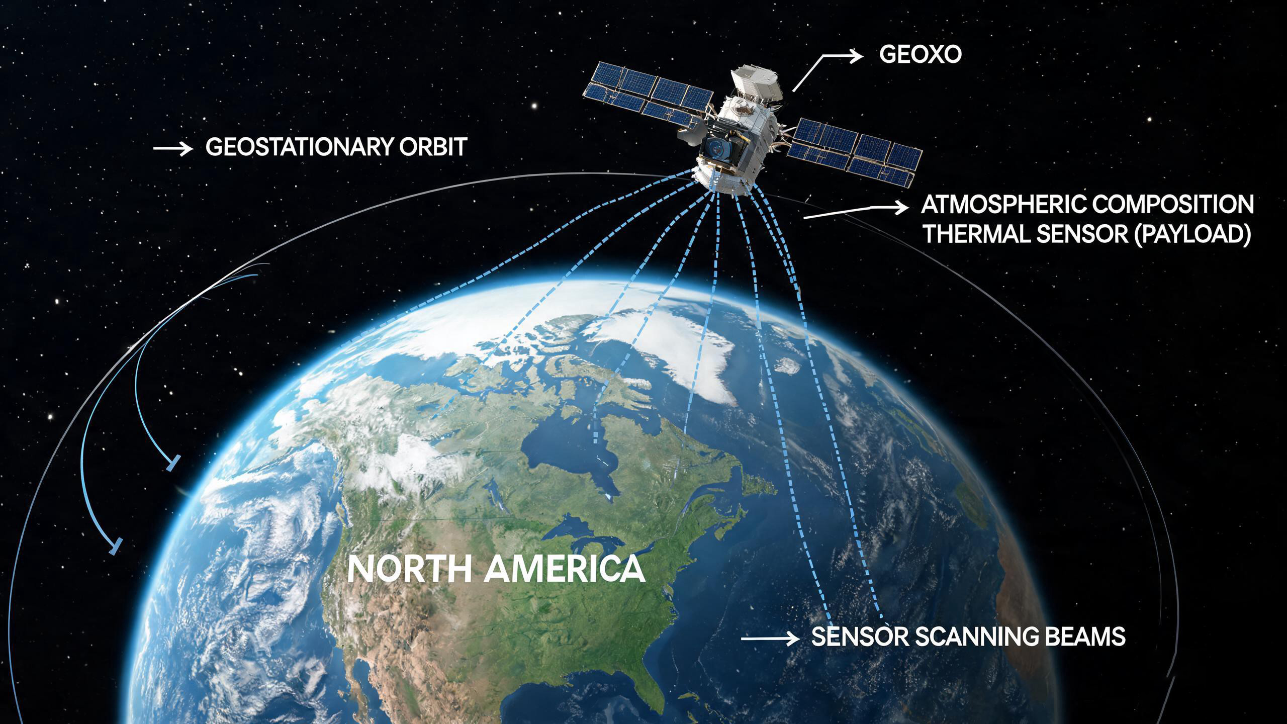
Fig 1: GeoXO was designed to carry a high-resolution thermal imaging spectrometer for wildfire smoke and atmospheric monitoring.
The 2026 Wildfire Crisis: 100 Million Americans Under Smoke
In July 2026, over 100 million Americans once again lived under wildfire smoke warnings. Hundreds of fires in Ontario, Canada, sent toxic plumes south across the Midwest, Mid-Atlantic, and Northeast, pushing air quality indexes to historically dangerous levels.
This was not an isolated incident. Smoke season is becoming an annual norm across North America. Yet at the very moment when demand for precise atmospheric thermal monitoring was highest, the capability to deliver it was being dismantled.
Current U.S. wildfire smoke monitoring still relies primarily on sparse ground-based air quality stations. Coverage is limited, updates cycle every hour, and the network cannot capture rapid smoke migration or concentration changes. Satellite thermal observation was the only technology capable of filling this gap — and that gap will now persist into the 2030s and potentially beyond.
What the GeoXO Cut Means for Thermal Imaging Satellite Monitoring
Starting in April 2025, the Trump administration directed NOAA to drastically reduce GeoXO's budget, citing "unsustainable costs." Two satellite missions were eliminated entirely. The central U.S. observation zone disappeared from the plan. Instrument contracts were terminated — including the Atmospheric Composition Instrument.
The official explanation: refocus on "core meteorological missions" rather than long-term climate and atmospheric monitoring. But the cut was not isolated. During the same period, the administration shut down multiple NOAA climate research databases, reduced hurricane hunter aircraft budgets, and systematically reviewed all federal research containing the phrase "climate change."
For the thermal imaging industry, this decision sends a troubling signal. It demonstrates how political priorities can abruptly erase decades of satellite sensor development, leaving critical gaps in global thermal monitoring infrastructure.
Global Thermal Imaging Satellite Race: China and Europe Accelerate
While the U.S. retreated, other nations advanced their thermal imaging satellite capabilities:
Europe's Sentinel Program
The EU's Copernicus Atmosphere Monitoring Service continues expanding global wildfire smoke tracking with upgraded Sentinel satellite thermal payloads.
China's Fengyun Series
China's Fengyun meteorological satellites are accelerating deployment of next-generation thermal imaging instruments for atmospheric and environmental monitoring.
Private Sector Innovation
Commercial satellite operators are launching small-sat constellations with thermal infrared sensors, offering high-revisit monitoring for wildfire and industrial emissions.
Ground-Based Thermal Networks
Advances in terrestrial thermal camera networks are partially compensating for lost satellite coverage in critical regions.
Dr. Susan Anenberg, Director of Environmental and Occupational Health at George Washington University, stated it directly: "As smoke events happen more frequently, we need more data, not less."
The Future of Wildfire Thermal Monitoring Without GeoXO
The cancellation of GeoXO's thermal imaging sensor creates a monitoring deficit that will last at least through the 2030s. Rebuilding a terminated satellite program costs far more than sustaining it — teams disperse, supply chains dissolve, and technical roadmaps fracture.
In the near term, three approaches will attempt to fill the gap:
- Denser ground sensor networks: Deploying more fixed thermal imaging cameras in wildfire-prone regions for early detection and smoke tracking
- Drone-based thermal patrols: Using UAV-mounted thermal cameras for rapid wildfire spotting and perimeter monitoring
- International data sharing: Relying on European and Chinese satellite thermal data, though with reduced spatial focus on North America
For buyers and integrators of thermal imaging technology, this geopolitical shift underscores the value of versatile, rapidly deployable thermal camera systems that can operate independently of satellite infrastructure.
Frequently Asked Questions
A: The Atmospheric Composition Instrument (ACI) was a high-resolution spectrometer designed to detect and map wildfire smoke, ozone, NO2, formaldehyde, and particulate matter in near-real-time across the continental United States from geostationary orbit.
A: Not entirely. Ground thermal cameras excel at early wildfire detection and localized smoke tracking, but they cannot provide the wide-area, cross-border coverage that satellites offer. The ideal system combines both layers.
A: Reduced satellite investment may shift demand toward terrestrial and airborne thermal imaging solutions. It also highlights the strategic importance of maintaining diverse thermal monitoring capabilities across platforms.
A: The first GeoXO satellites were scheduled for the early-to-mid 2030s. With the program cut, the earliest replacement atmospheric thermal monitoring capability may not arrive until the 2040s, if at all.
Reliable Thermal Imaging, Ground or Air
Whether for wildfire early warning, industrial emissions monitoring, or environmental surveillance, Owlshine thermal cameras deliver the performance you need — independent of satellite schedules.
Explore Thermal Camera Solutions